


| LIQUID - Canoeing Trip |
|
DIRECTIONS, PARKING, & MEETING LOCATIONS: | |
|
HILLSBOROUGH RIVER | |
|
MEET AT: Smiley's Coffee House by 8.00am  | |
|
-OR-
MEET AT: Morris Bridge Park Boat Ramp by 9.30am GPS: N28.05.918' W82.18.717'
Directions: From Tampa, go to the junction of I-75 and Fletcher Avenue (Exit 266). Go EAST 4.5 miles on Morris Bridge Road to the Morris Bridge Wilderness Park Boat Ramp (on Left / North side). | |
|
NOTE: John B. Sargeant Park is POINT 3, Morris Bridge Park is POINT 4
and Trout Creek Park is POINT 5 on the map below (click map to print)
 NOTE: John B. Sargeant Park is POINT 3, Morris Bridge Park is POINT 4
and Trout Creek Park is POINT 5 on the map above (click map to print) | |
|
Other Coordinates & Directions
Canoe Trip Ends at: Trout Creek Park
GPS: N28.05.274' W82.20.940'
Directions: From Tampa, go to the junction of I-75 and Fletcher Avenue (Exit 266). Go EAST 1/2 mile on Morris Bridge Road. The first left is Trout Creek Wilderness Park. Follow road 1 mile to canoe launch parking area. |
|
River Descriptions | |||
|
Hillsborough River (Apr 11, 2009)
An excerpt from Canoe Escape:
"Explore Tampa's premier attraction for bird watching, photography, canoeing, kayaking, and family memories.
Escape to nature on a downstream, quiet-water, paddling adventure through a 16,000-acre wildlife preserve. In all seasons the Hillsborough River astounds with its beauty and abundant wildlife. From the thousands of white ibis in the fall, the sightings of deer, wild hog, and turkey in the winter, the proliferation of songbirds in spring, and its cooling shade on a summer's day, the Hillsborough River brings a new surprise and delight around each bend. Bring your sense of adventure and paddle through this cypress swamp full of Florida's unique flora and fauna. Perhaps paddling close to a sunning 'gator, a threatened limpkin, turtles congregating on a log, or overtop of a large-mouthed bass will be the most prized memory of your trip. Whether this is your first-time, you are an experienced paddler, a vacationer or a local resident, the Florida you're looking for is just a short paddle away!" | |||
|
Silver River (DATE - TBD)
 An excerpt from FloridaAdventuring.com:
"The Silver river has been called "Florida's primo spring run." An average of 550 million gallons each day boil from beneath the earth at Silver Springs, the site of the largest limestone artesian spring in the world. From there, the clear spring water flows a little over 5 miles in an easterly direction until it converges with the dark, tannin-stained water of the Ocklawaha River.
The water is crystal clear. If you're a diver (or at least an avid snorkeler), you're probably going to want to get underneath the clear, inviting waters for a closer look at what lies below. The natural scenery along the river's wild and jungly banks complements the beauty of the river itself. You'll never have to worry about a real-estate development ruining these shores. The river flows right through the 5,000 acre Silver River State Park, so both the waterway and its surroundings are entirely protected.
Nearer to the springs, wild rhesus monkeys scamper among the trees doing monkey
 things-chattering, grooming, and chasing one another. Their antics can be entertaining, but unfortunately some people resort to feeding the monkeys, an action which is not only illegal, but also potentially dangerous. These are wild animals, the descendants of a troop released in the 1930s to lend an exotic air to jungle cruises along the river. Like many wild animals, they can bite. To prevent any feeding-frenzied monkeys from dropping into your boat, it's best to just observe them from a safe distance. things-chattering, grooming, and chasing one another. Their antics can be entertaining, but unfortunately some people resort to feeding the monkeys, an action which is not only illegal, but also potentially dangerous. These are wild animals, the descendants of a troop released in the 1930s to lend an exotic air to jungle cruises along the river. Like many wild animals, they can bite. To prevent any feeding-frenzied monkeys from dropping into your boat, it's best to just observe them from a safe distance. A voyage down the Silver River makes for an enjoyable and memorable day trip. It's one of the best day-long wild adventures Florida has to offer."
| |||
|
Caladesi Island (DATE - TBD)
 2007 "Best Beach" Winner
Dr. Beach announced his most recent list of the nation's Top 10 beaches on June 8, 2007... the #2 ranked beach in the US is: Caladesi Island State Park, one of the last undeveloped large barrier islands on the Gulf of Mexico... it claimed the #2 spot for the second year in a row... Caladesi is known for its soft sand and pristine natural habitat and is only accessible by boat.
 An excerpt from clubkayak.com:
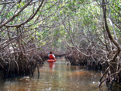
"Starting and ending at the south end of the marina, a 3.5 mile canoe trail leads paddlers through mangrove canals and seagrass flats along the bay side of the island. In many places the mangroves totally enclose the trail forming tunnels teeming with small fish, crabs, birds and other wildlife. To help with navigation the trail is marked at strategic intersections with numbered white plastic poles. Note the poles mark the direction you should turn, i.e. if the pole is on the right side of the waterway, turn right. At one mile (marker 8), the canoe trail exits the mangroves offering a view of St. Joseph Sound and the Intercoastal waterway."
| |||
|
Fort De Soto (DATE - TBD)
 "Dr. Beach" Named Fort De Soto Park's North Beach America's Best "Dr. Beach" Named Fort De Soto Park's North Beach America's BestAn excerpt from beachhunter.net:
"Fort Desoto Park in St. Petersburg, Florida has some excellent kayaking waters. Most of the water in the park is relatively shallow and protected and provides shelter for dolphins, manatees, wading birds, shorebirds, snook, mullet, redfish, trout, and scores of other varieties of wild creatures. You might not think that being so close to the cities of St. Pete Beach and St. Petersburg would allow you to enjoy this much natural beauty and quiet, but it really does exist here in this beautiful island park."
 | |||
|
Rainbow River (DATE - TBD)
 An excerpt from the St Pete Times:
"Though options for water sport in Florida are plentiful, one of the best places to indulge it is the 5.8-mile Rainbow River, about two hours north of Tampa. This pristine river system discharges nearly 500-million gallons of cool, clear water a day, making it the fourth largest freshwater spring in Florida and the eighth largest in the world.
With a year-round temperature of 72 degrees, the river is a haven for those looking to beat the heat in a kayak, canoe or tube. ...Just 14 feet at its deepest, the Rainbow River is so clear you can see its bottom, waves of grass swaying below in some spots, craggy rock formations filled with silvery bursts of tiny fish in others.
Sharp-eyed snorkelers sometimes catch a glimpse of fossils or stone tools left by the area's first inhabitants, but such relics are protected by law and must be left alone. Anyway, some of the best sights are above the surface - the many creatures that make their homes in and around the river. Families of turtles can be seen sunning themselves on fallen cypress stumps, lined up in neat rows, largest to smallest. Red-tailed hawks and the occasional bald eagle soar overhead. Great blue herons and snowy egrets tiptoe along the shore, scanning for lunch."
| |||
|
Weedon Island (DATE - TBD)
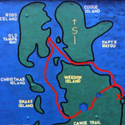 (Weedon Paddling Trail Map) An excerpt from the St Pete Times:
"This 1,046-acre park has some of the best fishing and canoeing in the state. The 4-mile canoe trail
will show you Weedon at its wildest. The mangrove islands and narrow passes will challenge paddlers of all skill levels. Accomplished paddlers will finish the trail in two hours but plan for three if you want to stop and enjoy the sights."
An excerpt from clubkayak.com:
"Weedon Island Preserve is a 1,046 acre park in Pinellas County that is home to many different species of wildlife and plants. The park was established for preservation and education and is listed on the National Register of Historic Places. For the paddlesport enthusiast, Weedon Island offers two canoe trails only minutes from St. Petersburg, Largo and Pinellas Park. In many locations, the mangroves grow so they form a canopy (tunnel).
Weedon Island has a very colorful and long history. The island was originally inhabited by early Native Americans. For the careful observer, it's easy to spot elevated sections of ground that may be shell middens or burial mounds."
| |||
|
Largo Central Park Nature Preserves (DATE - TBD)
An excerpt from the City of Largo's website:
"Largo Central Park Nature Preserve is a 31-acre nature park virtually surrounded by
water. The park is home to hundreds of wildlife species for viewing. Over 130 species of birds, otters, red fox, American alligator, marsh rabbits, wild turkey, and bats all feed or live within the park. A 5-mile kayak/canoe route begins at the park and ends at Park Boulevard."
An excerpt from the St Pete Times:
"Florida has long been known as a haven for flatwater kayakers, from paddling atop beautiful bays and along ocean shores to navigating the Everglades. Largo is promoting its own kayak adventure, a challenging 5-mile urban trek that begins at Largo Central Park Nature Preserve and twists its way to Lake Seminole Park. The route winds kayakers through back yards and under city roads, providing unique challenges..."
 | |||
|
Weeki Wachee (DATE - TBD)
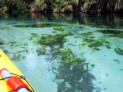 Weeki Wachee River - Crystal Clear Water
An excerpt from clubkayak.com:
"The spring and river are what makes Weeki Wachee truly special. Weeki Wachee is a first magnitude spring discharging over 64 million gallons of crystal-clear water a day. Along the river an observant paddler will see many types of animals including the famous Florida (West Indian) manatee, raccoons, otters and numerous birds. It's easy to spot ducks, ibis, pelicans, herons, osprey, wood storks and cormorants. The Weeki Wachee River eventually meets the Gulf of Mexico near the small village of Bayport."
| |||
|
Alafia River (DATE - TBD)
 An excerpt from florida-outdoors.com:
"The Alafia River Canoe Trail is officially designated as part of Florida's Statewide System of Greenways and Trails. This river, located an hour from downtown Tampa, is a narrow, twisting trail that begins at Alderman's Ford County Park. Large oak, cypress and cedar trees line the banks and form a canopy overhead. Paddlers share the peace and quiet with wading birds and turtles. The Alafia is a fairly swift river, especially for central Florida, and some small shoals are exposed in low water. The shoals are not dangerous, but do require some paddling skill."
| |||
|
Rock Springs Run [Wekiva River] (DATE - TBD)
An excerpt from canoewekiva.com:
"Whether you're young or old, expert or novice, a canoe trip along the breathtaking and pristine Wekiva River in Central Florida is an adventure you'll never forget.
One of Florida's two Federally designated "Wild and Scenic Rivers," the Wekiva River is home to an incredible variety of wildlife including Alligators, Great Blue Herons, Great Egrets, Limpkins, Little Blue Herons, Tricolored Herons, Woodpeckers, Swallow-tailed Kites, Florida Black Bears, White-tailed Deer, River Otters, Fox, and numerous subtropical birds. As you paddle slowly along with the gentle current, you'll marvel at the centuries-old oak trees that line the river's banks creating an inviting canopy from the noon day sun. The name 'Wekiva' comes from the Creek Indian word for "flowing water." If wet is what you want, just immerse yourself into the crystal clear waters of the Wekiwa Springs that pumps out an amazing 42 million gallons of cool fresh water daily!"  Crystal Clear Spring Water
| |||
|
"Cotee" [Pithlachascotee] River (DATE - TBD)
 An excerpt from coteeriverpaddleguides.com:
"This intimate river in Port Richey is a great trip for paddlers of all skill levels! Explore
the coastal creeks and mangrove tunnels that are home to egrets, pelicans, osprey and heron. Raccoons, mink and the occasional otter make their homes along the shallow coast and lucky paddlers could encounter dolphins and manatees swimming the warm flats on this day-long paddling adventure..."
An excerpt from makaikayak.com:
"The Pithlachascotee River is an urban river located in the city of Port Richey on Florida's central Gulf Coast. A trip along the Cotee (pronounced coat-e), as locals call it, offers canoeists the opportunity to paddle twisty and shallow streams, a wide tidal influenced river and numerous saltwater bays.
The upper part of the Pithlachascotee River is an official canoe trail as part of Florida's Statewide System of Greenways and Trails system. The 5 mile trail starts very narrow and shallow by the Rowan Road bridge and finishes at Francis Avenue City Park."
| |||
|
Cross Bayou (DATE - TBD)
DOLPHINS SPOTTED HERE REGULARLY
An excerpt from the blueways of pinellascounty.org:
"Cross Bayou is War Veterans' Park (owned and operated by Pinellas County and consists of 122 acres located on Boca Ciega Bay). ...To the northeast is the Cross Bayou canal. This area has a number of spoil islands and vegetation communities, and offers excellent opportunities for wildlife viewing, including dolphins, manatees, egrets and various species of shorebirds. Continue to paddle through the canal and you will come to the entry for Joe's Creek Preserve. This Pinellas County Preserve is host to a variety of species of animals including birds and fish. There is a landing site roughly one-half mile from the entrance to the creek if you choose to stop and rest. This area can be tidally influenced. From this launch site, it is also possible to circumnavigate Treasure Island.
| |||
|
Do 1 or all 12... Come enjoy the beauty of God's playground! | |||


NEXT LIQUID: April 15, 2006
NEW LOCATION: FT DeSOTO
|
--------------------------------------------- |
OTHER GTD PUBLIC EVENTS |
--------------------------------------------- |
|
[MOGUL] [HYDRO] [SPLASH] [X-FL] [GRUNGE] [GO VERTICAL] [CRANK] [THE ISLANDER] [NOMAD] | ||

|
LIQUID INFO |
|
TRIP | ||||
|
ADVENTURE |
2.0 - ROBUST |
RUGGED |
1.0 |
$20 |
|
LIQUID SUMMARY |
|
LIQUID is GTD's canoe day trip that is open to the public. Our 1 day Christ centered paddling trek will take place along the Ft De Soto Canoe Trail.FT De SOTO WAS NAMED THE BEST BEACH IN THE ENTIRE UNITED STATES IN 2005! This spectacular trail is found at the mouth of Tampa Bay. |

| EVENT: | LIQUID - Canoeing Day Trip |
| DATE: | April 15, 2006 (Saturday) |
| LOCATION: | Ft De Soto Canoe Trail; Start/Finish = meet on the beach just a few hundred yards east of the BAY PIER. SEE DIRECTIONS & MAP BELOW |
| GROUP NAME: | Open To The Public |
| COST: | $20/person (includes canoe, gear, & lunch) |
| SESSION 1 (9am-Noon): | Meet @ 8.30am at Ft De Soto's Bay Pier Parking Lot |
| SESSION 2 (1pm-4pm): | Meet @ Noon on the beach just a few hundred yards east of Ft De Soto's Bay Pier |
| COOKOUT (Noon-1pm): | A cookout is included with your activity and will take place from Noon-1pm. |
| ACCOMMODATIONS: | Paradise - Ft De Soto(Named The BEST BEACH in America in 2005) |
| WHAT IS INCLUDED: | COOKOUT, Canoes, Paddles, Life Vests, Dry Containers, Full Time Guides, Daily Devotions, & a Lifelong Memory! |
| WHAT'S NOT INCLUDED: |
Drinking Water, Water Bottles, Items Listed on your Checklist |
|
REGISTRATION: |
Online in the Event Calendar or Call The GTD Adventure Line @ 727!394!9483! |
| EMERGENCY PHONE #: | GTD Emergency Phone #: 727.692.5296 |
| REFUND POLICY: | SORRY, NO REFUNDS DUE TO INCLEMENT WEATHER! |
|
DIRECTIONS, PARKING, & PICK-UP SPOT: | |
|
| |
| Directions To Ft De Soto: Take 275 south, exit (Pinellas Bayway/ 682) go west, Pass the toll booth (.50 cents) ,Turn left at the second light onto "679" heading south toward Ft De Soto. You will have another Toll (.35 cents) at the entrance to the Park. Drive south until you get to the end (a "T" intersection). Take a right at the "T" and go a few hundred yards. Turn left into the BAY PIER parking lot. We will have a canopy set up on the beach just a few hundred yards east of the Bay Pier (NOT to be confused with the Gulf Pier) Alternate Ft. Desoto Activities: Bike, hike, canoe, kayak, windsurf, Call Doug's cell if you have any questions (727.692.5296) |
|
- CHECKLIST - | |||
|
MANDATORY GEAR |
OPTIONAL GEAR |
CLOTHING |
TOILETRIES |
| Trail Snacks | Camera & Film | Swimsuit |
Not Applicable |
| Drinking Water 2 Water Bottles |
Favorite Snacks | Activity Shorts | |
| Sunglasses | Energy Bars | Activity Shirts | |
| Plastic Bag (wet clothes) | $$ For GTD T-shirts & Gear | Sandals / Shoes | |
| Zip-Lock Bags (very handy) | Hat | ||
| Insect Repellent | Towel | ||
| Sun Screen / Lip Balm | Change of Clothes for Ride Back | ||
| Eyeglasses / Contacts (if applicable) |
DON'T BRING: |
||
| Any Necessary Meds (if applicable) |
Jewelry |
||
| Valuables | |||
| SIGNED WAIVER (Can not participate without signing) Click "SIGNED WAIVER" to download. (if under 18 then waiver must be signed by the participant & his/her parent/guardian) | |||
